

Exploring the outdoors often means venturing into areas without reliable cell service or familiar landmarks, so having a dependable navigation tool is essential for safety and confidence on the trail. Handheld GPS units are built to deliver accurate location data, route tracking, and rugged performance in all kinds of terrain and weather. They help you stay on course when maps or phones aren’t enough.
This guide highlights the best handheld GPS units for outdoor adventures, what key features to consider like battery life, durability, and mapping capabilities, and how to choose the right model for your needs. You’ll find clear recommendations, comparisons of performance and ease of use, and tips to help you pick a GPS that enhances your navigation and outdoor experience.
1. Garmin Etrex 10

The Garmin 010-00970-00 eTrex 10 Worldwide Handheld GPS Navigator is ideal for outdoor enthusiasts, hikers, campers, and adventurers who need a reliable and easy-to-use GPS device. If you require a compact, durable, and accurate navigator to track your routes and explore new terrains without relying on a smartphone, this device is a perfect choice. Its simplicity and worldwide mapping capabilities make it suitable for both beginners and experienced users.
Pros:
- Compact and lightweight design for easy portability
- Worldwide basemap with shaded relief for enhanced navigation
- Durable, yellow and black casing suitable for rugged outdoor use
- Long battery life ensuring extended use during trips
- Simple interface with easy-to-read display for quick access to information
Cons:
- Basic edition lacks advanced features like touchscreen or high-resolution maps
- No preloaded detailed maps, requiring additional purchases for in-depth navigation
- Screen size may be small for some users needing more detailed visual data
The Garmin eTrex 10 features a compact design with dimensions approximately 4.06 inches in height, 1.3 inches in width, and 2.13 inches in length, weighing just over 0.3 pounds, making it highly portable for any outdoor adventure. Its bright yellow and black casing not only enhances visibility but also adds to the device’s rugged durability, ensuring it withstands harsh environmental conditions. The worldwide base map with shaded relief provides users with a reliable overview of their surroundings, which is essential for navigation in unfamiliar areas.
Users benefit from the device’s straightforward interface that allows easy waypoint marking, route tracking, and navigation without the complexity of more advanced GPS units. The long-lasting battery life supports extended expeditions, minimizing the need for frequent charging. While it is a base model, its focus on essential GPS functions makes it an excellent tool for those who want dependable navigation without unnecessary features, thus optimizing ease of use and reliability in the field.
To buy this product, click here.
2. Handheld Gps For Hiking

The Handheld GPS for Hiking by NiesahYan is ideal for outdoor enthusiasts who require a reliable, durable, and easy-to-use navigation device. Perfect for hikers, campers, and adventurers, this compact GPS navigator is designed to withstand rugged environments while providing accurate location tracking with its multi-GNSS support. If you need a robust and waterproof GPS with an extended battery life and clear visibility even in bright sunlight, this device is a great choice.
Pros:
- Rugged and waterproof design ensures durability in harsh outdoor conditions
- 3.2″ sunlight readable screen provides clear visibility in bright environments
- Compact and lightweight, making it easy to carry on any adventure
- Includes USA Topo Map for detailed navigation and route planning
- Multi-GNSS support enhances location accuracy by accessing multiple satellite systems
- Extra battery life allows for extended use without frequent recharging
Cons:
- Screen size might be small for users preferring larger displays
- Limited to USA topo maps; may require additional maps for international use
This handheld GPS navigator is engineered to offer precise and dependable navigation for outdoor activities. Its rugged and waterproof build means it can endure tough weather and terrain, ensuring your device stays functional regardless of the environment. The bright 3.2-inch screen is optimized for sunlight readability, making it simple to view maps and directions even under direct sunlight, which is crucial for hikers and adventurers spending long hours outdoors.
The device’s support for multiple global navigation satellite systems (Multi-GNSS) significantly improves positional accuracy and speed, allowing users to confidently track their location. Additionally, the inclusion of detailed USA Topo Maps helps users plan routes efficiently and explore new areas with confidence. Its compact design and lightweight construction make it easy to carry without adding unnecessary bulk, and the extended battery life ensures you stay connected to your path during long excursions without worrying about power shortages.
To buy this product, click here.
3. Garmin Gpsmap 65s
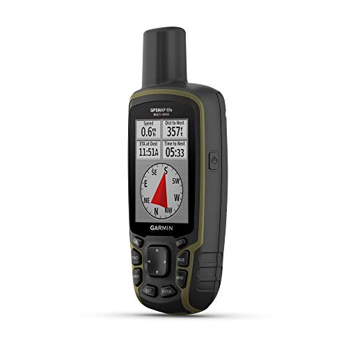
The Garmin GPSMAP 65s is ideal for outdoor enthusiasts, hikers, and adventurers who require a reliable and rugged handheld GPS device with advanced navigation features. Those who often explore remote areas without cellular coverage will benefit from its robust satellite support and multi-band technology, making it perfect for serious trekkers and geocachers.
Pros:
- Button-operated interface for easy use in all weather conditions
- Includes an altimeter and compass for comprehensive navigation
- Expanded satellite support with multi-band technology for improved accuracy
- 2.6″ color display offers clear visibility in various lighting environments
- Compact and lightweight design enhances portability during long excursions
Cons:
- Smaller screen size may not be ideal for users preferring larger displays
- Button operation might have a learning curve for users accustomed to touchscreen devices
- Limited color options, available only in black
The Garmin GPSMAP 65s excels with its multi-band technology, which utilizes signals from multiple satellite systems to provide highly accurate positioning even in challenging environments such as deep canyons or dense forests. Its built-in altimeter and compass add essential data points for users who rely on precise elevation and directional information during their outdoor activities. This device’s rugged construction ensures durability, making it resistant to harsh weather and rough handling.
Additionally, the 2.6-inch color display delivers clear, vibrant visuals that enhance map readability and navigation, even under bright sunlight. The button-operated design is tailored for users who need dependable control without worrying about screen smudges or unresponsiveness caused by gloves or wet conditions. Weighing only 0.48 pounds and measuring compactly, the Garmin GPSMAP 65s provides a perfect balance of functionality and portability for adventurers on the go.
To buy this product, click here.
4. Zl180 Handheld Gps For Surveying

The ZL180 Handheld GPS for Surveying is ideal for professionals and enthusiasts involved in land measurement, such as surveyors, ranchers, gardeners, and farmland managers. If you require a reliable, high-precision, and rugged device to accurately measure distances over large outdoor areas including parking spaces, this equipment is tailored to meet those needs.
Pros:
- High precision measurements ensure accurate surveying results.
- Rugged design built to withstand tough outdoor conditions.
- Compact and portable with dimensions of 1.1 x 2.3 x 5.5 inches for easy handling.
- Versatile usage suitable for ranches, gardens, farmland, and parking areas.
- Manufactured and branded by NiesahYan, assuring quality and reliability.
Cons:
- May require some technical knowledge for optimal use.
- Limited information on battery life and connectivity options.
The ZL180 Handheld GPS is engineered with precision and durability in mind, making it an excellent tool for surveying tasks. Its compact size allows for easy portability without compromising on accuracy, which is crucial for professionals needing reliable distance measurements in varied terrains. The rugged construction ensures it can endure harsh environmental conditions often encountered in outdoor surveying activities.
Users benefit from its straightforward design that focuses on delivering exact results across multiple applications, from measuring farmland boundaries to assessing parking area dimensions. Being a product of NiesahYan, it carries the assurance of quality manufacturing standards that enhance user confidence and device longevity. This equipment simplifies the surveying process, saving time and reducing errors in field measurements.
To buy this product, click here.
5. Garmin Etrex Se Gps Handheld Navigator

The Garmin eTrex® SE GPS Handheld Navigator is ideal for outdoor enthusiasts, hikers, campers, and adventurers who require a reliable and durable navigation device. If you need a compact, lightweight GPS that offers extended battery life and the ability to connect wirelessly, this device is perfect for you. Its robust features make it suitable for those navigating challenging terrains or exploring remote areas where accurate positioning is essential.
Pros:
- Extra Battery Life ensures longer usage during extended trips without frequent recharging.
- Wireless Connectivity allows for easy data transfer and updates, enhancing user convenience.
- Multi-GNSS Support provides accurate and reliable positioning by accessing multiple satellite systems.
- Sunlight Readable Screen offers clear visibility even in bright outdoor conditions.
- Compact and lightweight design (0.34375 pounds) makes it easy to carry on any adventure.
Cons:
- Limited color options, available only in Black/Yellow.
- Screen size might be small for users preferring larger displays.
- May require some learning curve for beginners unfamiliar with GPS devices.
The Garmin eTrex® SE features a durable build with dimensions optimized for portability, making it an excellent companion for outdoor activities. Its multi-GNSS support means it can connect to various satellite systems including GPS, GLONASS, and Galileo, which enhances positioning accuracy and reliability even in challenging environments like dense forests or deep valleys. This feature is particularly beneficial for users who require dependable navigation without signal loss.
Another standout feature is the sunlight readable screen, designed to maintain screen visibility under bright conditions, reducing eye strain and improving map readability. Coupled with its extended battery life, this device supports long excursions without the worry of running out of power. The wireless connectivity adds to the convenience by enabling easy updates and sharing of waypoints or routes, ensuring users stay connected and up to date with their navigation data.
To buy this product, click here.
6. Niesahyan A6 Handheld Gps For Hiking

The NiesahYan A6 Handheld GPS is ideal for avid hikers, outdoor enthusiasts, and adventurers who need a reliable and durable navigation device. If you frequently explore remote trails, camp in rugged environments, or require precise navigation tools with extended battery life, this GPS navigator is designed to meet your demands. Its waterproof and rugged build makes it perfect for those who face challenging weather and terrain conditions.
Pros:
- Rugged waterproof design ensures durability in tough outdoor conditions
- Long-lasting 20 hours of battery life for extended trips
- Two versatile navigation modes to suit different tracking needs
- Clear 2.4″ color display for easy map reading and navigation
- Built-in GPS compass and moon phase information for enhanced outdoor planning
Cons:
- Relatively compact size may be difficult to operate with gloves
- Screen size might be small for some users who prefer larger displays
- Lack of advanced connectivity features like Bluetooth or Wi-Fi
The NiesahYan A6 Handheld GPS stands out with its rugged and waterproof construction, making it a dependable companion for any outdoor expedition. Its compact design, measuring just 6.1 inches in length and weighing under a pound, ensures easy portability without compromising performance. The device’s clear 2.4-inch color display enhances usability by providing vivid map visuals and navigational data, which is essential when trekking through dense forests or mountainous terrains.
Featuring two navigation modes, this GPS navigator caters to both casual hikers and serious explorers, allowing users to customize their experience based on their specific needs. The integrated GPS compass and moon phase information offer additional value for planning activities like night hiking or fishing. Moreover, the impressive 20-hour battery life supports long journeys without the worry of frequent recharging, ensuring continuous guidance throughout your adventure.
To buy this product, click here.
7. Niesahyan Zl190 Handheld Gps

The NiesahYan ZL190 Handheld GPS is ideal for professionals and enthusiasts involved in surveying tasks, especially those working in mountainous terrain and flat fields. Whether you are a land surveyor, geologist, or an outdoor researcher, this high precision GPS surveying equipment offers reliable and accurate data collection for challenging outdoor environments.
Pros:
- High precision GPS ensures accurate surveying results
- Compact and lightweight design (7.0 x 2.0 x 1.0 inches; 0.49 pounds) for easy portability
- Durable build suitable for rugged outdoor use
- Versatile for use in both mountainous slopes and flat terrains
- Manufactured by NiesahYan, a trusted brand in surveying equipment
Cons:
- Limited additional features beyond core GPS surveying functionality
- Small size may result in a smaller screen, potentially affecting visibility in bright outdoor conditions
The NiesahYan ZL190 Handheld GPS offers a perfect balance between portability and precision. Its compact dimensions make it easy to carry during extended fieldwork, while the advanced GPS technology provides reliable location data critical for accurate land measurement and analysis. The lightweight design reduces user fatigue, allowing professionals to focus on their surveying tasks without being weighed down by bulky equipment.
Designed specifically for outdoor use, the device performs well across different terrains, including mountainous slopes and flat fields. This versatility makes it a valuable tool for diverse applications such as construction planning, environmental studies, and land management. The robust construction ensures that it withstands harsh weather and rough handling, guaranteeing long-term use and dependable performance in the field.
To buy this product, click here.
8. Garmin Gpsmap 67i Rugged Gps Handheld

The Garmin GPSMAP 67i Rugged GPS Handheld is ideal for outdoor enthusiasts, adventurers, and professionals who require reliable navigation and communication in remote locations. Whether you are hiking, camping, or working in challenging environments, this device is designed for those who need robust GPS functionality combined with satellite messaging and emergency features.
Pros:
- Durable and rugged design suitable for harsh outdoor conditions
- Integrated inReach® Satellite Technology enabling two-way messaging anywhere
- Interactive SOS feature for emergency assistance
- Comprehensive mapping with preloaded maps and support for additional maps
- Lightweight and compact dimensions for easy portability
Cons:
- Requires subscription for satellite messaging services
- Screen size may be small for some users preferring larger displays
- Price point may be higher compared to basic GPS devices
The Garmin GPSMAP 67i combines advanced GPS capabilities with satellite communication technology, making it a versatile tool for navigation and safety. Its rugged construction ensures it can withstand tough environments, while the bright, high-resolution display offers clear map reading even in bright sunlight. Users benefit from the preloaded topographic maps and the ability to add custom maps, enhancing route planning and exploration.
One of the standout features is the two-way messaging enabled by inReach® technology, allowing users to stay connected even beyond cellular coverage. This feature is complemented by an interactive SOS system that connects directly with emergency responders, providing peace of mind during outdoor excursions. Overall, the Garmin GPSMAP 67i offers a reliable and comprehensive navigation and communication solution for those venturing off the grid.
To buy this product, click here.
Frequently Asked Questions
What Features Make Garmin Etrex 10 Ideal For Hiking?
Garmin eTrex 10 offers a rugged, waterproof design with a 3. 2″ sunlight-readable screen. It includes USA Topo maps and supports multiple satellite systems. Its compact size and extra battery life make it perfect for extended outdoor adventures.
How Does Garmin Gpsmap 65s Enhance Navigation Accuracy?
GPSMAP 65s features multi-band technology and expanded satellite support. It includes an altimeter and compass for precise outdoor navigation. The 2. 6″ color display ensures clear map visibility in various lighting conditions.
What Surveying Advantages Does Zl180 Handheld Gps Provide?
The ZL180 offers high precision and rugged construction suited for land surveying. It accurately measures distances on ranches, gardens, farmlands, and parking areas. Its durability and accuracy improve outdoor surveying efficiency.
How Long Does Niesahyan A6 Gps Battery Last?
NiesahYan A6 provides up to 20 hours of battery life. This long-lasting power supports extended hikes and outdoor activities without frequent recharging. It’s designed to be rugged and waterproof for tough environments.
What Communication Features Are In Garmin Gpsmap 67i?
GPSMAP 67i includes inReach satellite technology for two-way messaging and SOS alerts. It supports interactive SOS for emergencies and provides detailed mapping. This makes it ideal for remote outdoor expeditions needing reliable communication.
Can Niesahyan Zl190 Handle Mountainous Terrain?
Yes, NiesahYan ZL190 is designed for high-precision surveying in mountainous and flat outdoor areas. It’s rugged and reliable for challenging terrains, ensuring accurate land measurements in diverse environments.
Conclusion
Choosing the right handheld GPS unit makes your outdoor trips safer and more enjoyable. Each model offers unique features like durability, battery life, and precise navigation. Whether you need a simple device for hiking or a high-precision tool for surveying, options like Garmin and NiesahYan cover different needs.
Think about how long you will use it and what kind of terrain you will explore. A reliable GPS helps you stay on track, find your way back, and share your location if needed. With the right handheld GPS, your adventures become less stressful and more fun.
Take time to compare features and pick one that fits your outdoor lifestyle. Safe travels and happy exploring!


